Mine water heat opportunity maps for Wales: background and guidance
How to use our mine water heat map.
This file may not be fully accessible.
In this page
Executive summary
Decarbonisation of heat is one of our greatest challenges, and in Wales heat accounts for approximately 50% of the total energy use. Wales also has some of the oldest and least efficient housing stock in Europe, with an estimated 45% of Welsh households at risk of fuel poverty. Welsh Governments Draft Heat Strategy supports the decarbonisation of the public sector by 2030 and homes, industry and businesses by 2050, with a vision that clean affordable heat will be available to all.
In Wales it is estimated that about 50% of the population live with in ex-coal mining areas across Wales. As a result there is a large heat demand in coalfield communities, for homes, schools, businesses and places of work.
The legacy of coal mining can often be associated with liabilities, however the vast underground networks of mines can also provide opportunities for achieving net zero. Where water filled, abandoned underground coal mines occur, it is possible to use this water as a source from which to recover low carbon, secure heat and distribute via heat networks. Dependant upon drilling depths, the source temperatures of mine water are likely to be between 10-20°C and remain relatively stable throughout the year – including during winter when heat is required most.
The concept of using mine water for heat recovery has been proven in Gateshead, where a 6MW mine water heat network supplies affordable, low carbon, secure heat via a network of over 5km of pipes to businesses, homes, and public buildings.
Recognising the potential for mine water heat to play a part in Wales’ net zero ambitions, Welsh Government have funded this project which includes;
- Open access mine water heat opportunity maps to identify areas where open loop mine water heat schemes could be investigated. The opportunity maps can be downloaded for free from DataMapWales.
- Open access Local Authority area summary reports describing the mine water setting and highlighting the best areas for mine water heat schemes. The area summary reports can be downloaded for free.
To create the mine water heat opportunity maps, technical experts in the Coal Authority applied a methodology that enabled the ranking of underground coal mine workings across Wales into three categories; “Good”, “Possible” and “Challenging” opportunities. Factors including depth to workings, mine water status and occurrence of multiple seams were included and a detailed description of the method can be found in the main body of this report.
Information on mine water discharges or treatment schemes was also assessed, and where the theoretical heat recovery was >0.5MW the sites have been included as ‘points’ on the mine water heat opportunity map.
The ranking terminology is intentionally simple and is designed to complement high level decision making for example as part of Local Area Energy Planning. Our mapping has identified numerous opportunities to investigate mine water heat schemes with opportunities in South Wales and in north east Wales.
Individual reports have been produced for the following local authority areas;
- Blaenau Gwent County Borough Council
- Bridgend County Borough Council
- Caerphilly County Borough Council
- Carmarthenshire County Council
- Flintshire County Council
- Merthyr Tydfil County Borough Council
- Neath Port Talbot Council
- Rhonda Cynon Taf County Borough Council
- City and County of Swansea Council
- Torfaen County Borough Council
- Wrexham County Borough Council
Although coal mine workings occur in Anglesey, Pembrokeshire and Powys our method did not highlight any opportunities and thus area reports have not been produced.
We recommend that the opportunity maps and this report are used to highlight locations for more detailed feasibility studies to support mine water heat networks or smaller mine water heat schemes to individual end users.
Provided as open access maps they can be integrated into Local Area Energy Plans or compared to Local Development Plans, or used by other stakeholders (from both the public or private sector) with large or small property portfolios to undertake high level assessments of where mine water heat could be viable.
Following this exercise discussions with the Coal Authority – who own the majority of coal and mine workings on behalf of the UK Government – are recommended along with discussions with the environmental regulator, Natural Resources Wales, before more detailed site specific feasibility studies are completed.
This work represents the first fully open access country-wide mine water heat opportunity map and area summary reports that take into account the full range of workings and discharges. We hope that this provides a ‘kick start’ to the development of mine water heat schemes in Wales, transforming its industrial heritage into an opportunity for a secure, equitable, low carbon future.
1. Introduction
1.1: How to use the opportunity maps and reports
This overarching report, mine water heat opportunity maps and local authority area reports are intended to be a tool to guide energy planners, developers and local authorities to where open loop mine water projects could warrant further consideration.
Mine water heat opportunity maps can be downloaded as open access files from DataMapWales. Provided as georeferenced files that can be integrated with geographical information systems they rank areas into “Good”, “Possible” and “Challenging” categories, which are defined within this report.
Local Authority area summary reports describe the occurrence of coal mine seams and current mine water setting. The reports describe the areas that could be suitable for mine water heat schemes, including open loop borehole schemes or heat recovery from gravity driven discharges or mine water treatment schemes. It is recommended that any potential sites identified in this series of reports or using the mine water heat opportunity maps are followed up with discussions with the Coal Authority.
Individual reports have been produced for the following local authority areas;
- Blaenau Gwent County Borough Council
- Bridgend County Borough Council
- Caerphilly County Borough Council
- Carmarthenshire County Council
- Flintshire County Council
- Merthyr Tydfil County Borough Council
- Neath Port Talbot Council
- Rhonda Cynon Taf County Borough Council
- City and County of Swansea Council
- Torfaen County Borough Council
- Wrexham County Borough Council
Although coal mine workings occur in Anglesey, Pembrokeshire and Powys our method did not highlight any opportunities and thus area reports have not been produced.
1.2: Open Loop Systems
There are two principal configurations for recovering heat from mine water. These are open loop and closed-loop systems. This report and associated opportunity maps are focused on open-loop systems only.
Open-loop systems typically require the mine water to be pumped to surface via a borehole, shaft or where it can be intercepted from a gravity driven discharge or mine water treatment scheme. The mine water is typically passed through a primary heat exchanger which transfers the heat to a ‘clean’ loop in which the heat pump is situated. The heat pump raises the temperature from a typical 12-20oC to around 60oC for circulation to homes and
businesses.
The thermally spent water from the primary heat exchanger may be:
- Discharged/returned to the same set of mine workings from which it was abstracted;
- Discharged/returned to a different set of mine workings, either shallower or deeper,
but with clear evidence that it is connected to the abstraction workings; or, - Discharged to a surface watercourse, although this is likely to present different / additional regulatory requirements and additional investigations.
Depending on the water quality and the vulnerability of the receptor, the discharge water may require treatment. The type of open-loop system used, as well as the environment of operation, will determine environmental, permitting, licensing and treatment requirements.
2. Methodology
Each local authority area has been assessed for potential borehole-based mine water heat schemes, which have been ranked into a number of “Priority Opportunity Areas”. These areas have been designated to indicate where open loop mine water heat schemes could be investigated further. The following section outlines the assessment methodology, and the associated caveats.
2.1: Opportunity ranking criteria
Opportunity rankings for mine water heat potential have been developed by reviewing the following;
- Underground working depths: This is important as the depth to working influences drilling costs and potential complexity;
- Known mine water levels across mine water blocks (MWB): This is important as the depth to mine water directly influences the pumping costs and energy required to operate a scheme
- Recovery status of MWB (recovering or recovered): Recovered systems indicate that water levels will not change as mine water has reached its maximum level. Recovering systems indicate that water levels may yet rise and potentially become closer to surface. However, recovering systems can have additional challenges such as dry workings and migrating gas as water levels rise;
- Evidence of opencast mine workings: Where opencast mines have operated it is likely they have removed many of the coal seams and this is taken into account.
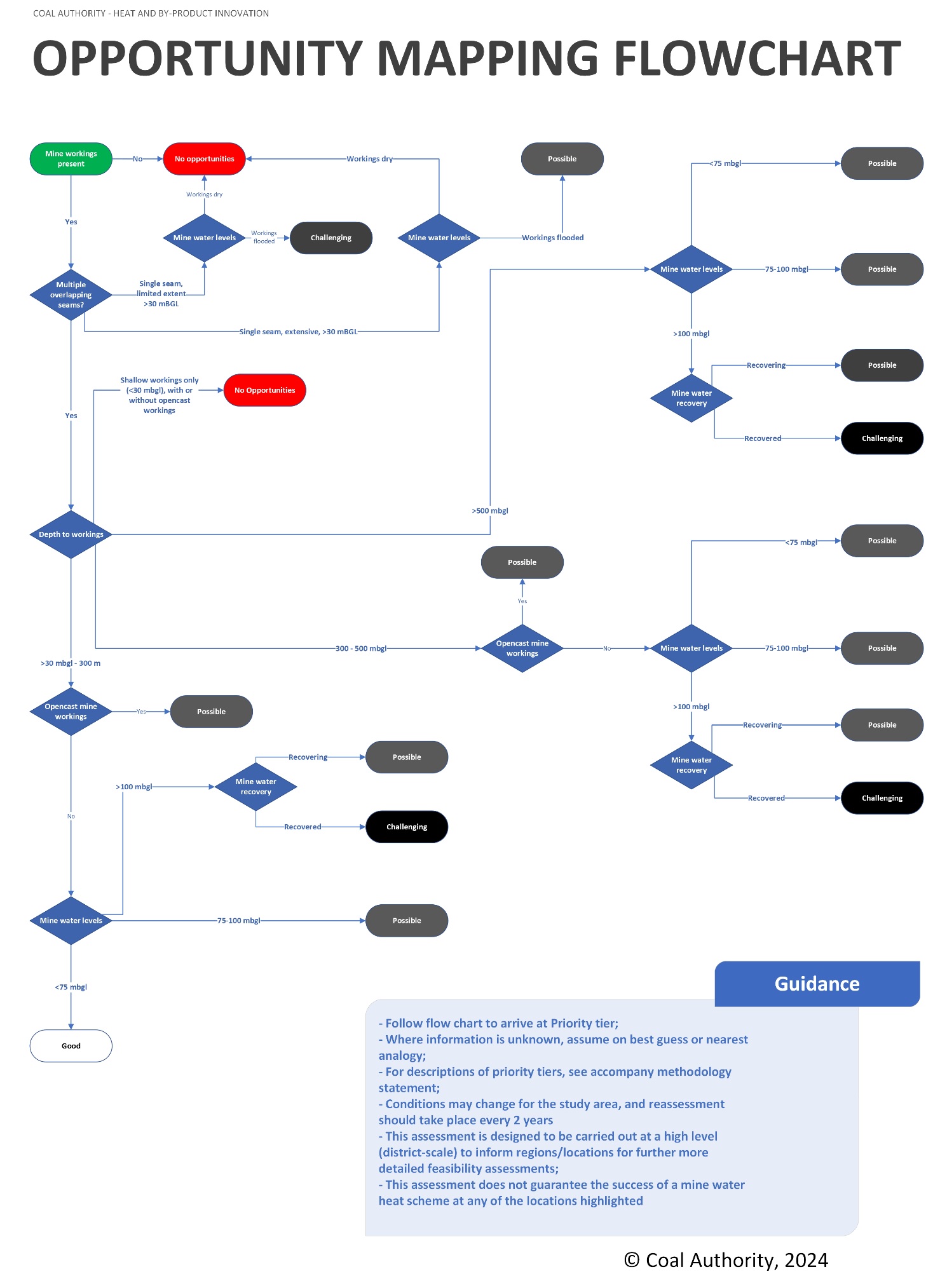
There are three levels of opportunities for mine water heat developments: “Good”, “Possible” and “Challenging”. The methodology and decision making process is detailed below and in Figure 1.
A number of “cut-offs” or groups have been designated for underground working depths and mine water levels. These allow for areas to be graded on the basis of whether the known data falls within a certain category. Areas are first assessed on whether there are overlapping workings present in an area, or if there is a single extensive seam.
Underground working depth cut-offs are taken as the following:
- <30 mBGL
- >30 – 300 mBGL
- 300 – 500 mBGL
- >500 mBGL
This is in line with current experience of the Heat and By-product Innovation Team at the Coal Authority. Shallow workings (typically <30 m below ground level) should be avoided, but can be mitigated for during the drilling process when there are deeper targets. Deeper workings may be well recorded as they are often more modern, but come at increased cost for drilling.
Mine water levels have been taken at the following cut offs:
- <75mBGL
- 75-100 mBGL
- >100 mBGL
This is in line with work by Walls et al. (2021) and the Coal Authority’s own pumping cost analysis tool. Recovery status is factored in to allow for the possibility that mine water levels may rise and reduce running/pumping costs for a system in future (improving the ranking of the area). Water levels should ideally not be artesian or too shallow (deeper than 20 mbgl) to allow for reinjection of mine water back into the target workings with minimal risk of surface egress. This will need to be assessed in detail at a site-scale, and has not been assessed extensively at this scale.
Additional factors that are considered in the criteria include whether there is knowledge of unflooded workings and mine gas in the area. These affect the fundamental feasibility of mine water heat in any particular opportunity area.
2.2: Opportunity ranks
The following criteria apply to each of the three different ranking categories; “Good”, “Possible” and “Challenging”. The flow chart in Figure 1 can be used to guide the user towards the appropriate rank, or the following criteria can be reviewed and satisfied.
2.2.1: Good opportunities
These areas represent where there appear to be ideal conditions for a mine water heat scheme to take place, with fewer challenges. All of the following criteria will be met, in order to classify an area as “Good”. However, these areas still require a site-specific assessment to determine local water levels, condition of the workings, and feasibility of developing a scheme.
- Multiple recorded underground coal mine workings overlap each other, and;
- Workings between 30 m and 300 m below ground level, and;
- Water level estimated to be approx. <75 m below ground level, and;
- Water levels have recovered or are recovering, and;
- Workings are flooded.
2.2.2: Possible opportunities
These areas represent where there appear to be challenges for developing mine water heat. If any of the conditions below are met, the area is to have “Possible” opportunities for mine water heat. These areas will need a thorough investigation, and may represent a good or poor opportunity in the future should conditions change.
- Workings are overlapping, and;
- Workings are flooded, and;
- Workings are near to or shallower than 500 m below ground level, or;
- Water levels are between 75-100 m below ground level, either recovering or
recovered, or; - Water levels are deeper than 100 m below ground level, but recovering, or;
- There is evidence of open cast coal mine workings, but with workings between 30 – 500 m.
2.2.3: Challenging opportunities
These areas represent where conditions do not appear favourable for developing a mine water heat scheme, and may not improve in the future. If any one of these criteria are met, the area is classified as “challenging”. It is not that a scheme could not be successful here, but that there would be a number of challenging barriers to overcome versus other opportunity areas for mine water heat.
- Workings may not be flooded, or;
- Workings are <30 m below ground level only, or;
- Workings are only >500 m below ground level with no shallower targets, or;
- Water levels >100 m, and are recovered, or;
- There are known issues with mine gas, or;
- There is a single seam, which is fully flooded, and not impacted by opencast workings.
Single seam opportunities have been included as “challenging”, and would require a thorough appraisal to determine whether the nature of the workings would support a scheme. Having a borehole based scheme into a single seam can result in rapid “short circuiting” of a heat scheme, as colder spent water can rapidly move to the abstraction well after reinjection.
2.2.4: No opportunities
These areas are where there is recorded workings that meet the following two criteria:
- There are no coal mine workings
- There is evidence of open cast coal mine workings, with workings <30 m only, or;
- There is only a single seam of limited extent.
These conditions are tied to shallow workings or single seam workings or workings likely removed by opencast coal mining.
2.2.5: Caveats for ranking criteria
A number of aspects relevant to borehole-based mine water heat schemes have not been considered as part of opportunity assessment criteria. A number of these are due to the quality of the data at the resolution needed for a regional assessment, where some information is often more site-specific.
The following list of caveats indicate what information has not been included as part of the assessment criteria, and would normally be reviewed as part of more detailed feasibility studies:
- Mine Water Treatment Schemes (MWTS) – If an active, passive or proposed mine water treatment scheme, owned and operated by the Coal Authority as part of its statutory duties is located within the same or connected mine water block, an assessment and interaction agreement will need to be made to ensure that the proposed mine water heat scheme will have no detrimental impact on the MWTS;
- Mine Water Levels and Local Topography: Potential areas highlight where the conditions above are broadly met, but mine water level will vary depending on surface topography and interconnectivity between monitoring points and adjacent mine workings;
- Geology: Geology and geological structures (such as faults) are not accounted for in the ranking system, which may impact on drilling costs and complexity, and the wider hydrogeology of the region;
- Type of Workings: The type of mine workings are not accounted for due to the incomplete and inconsistent nature of the digital records, where it is often necessary to refer back to the original abandonment plans at a site-specific scale;
- Age of Workings: Age of workings have not been assessed at a regional scale and will need assessment on an area-by-area basis;
- Probable workings: are not accounted for within the grading criteria, and will need to be assessed on a site-specific scale;
- Gas: Gas risk assessments will be needed at every site, and only broad knowledge of gas risks in the area have been applied during any opportunity assessment;
- Mine Water Chemistry: the ranking does not take into account mine water chemistry as this can be highly variable and often site-specific;
- Developer Risk Appetite: The ranking criteria does not take into account the risk appetite of the potential MWH developer, which will have an impact on the assessment of the mine water heat opportunity;
- Heating and Cooling Demands: the ranking does not take into account existing or planned areas of heating and cooling loads, which would drive demand and dictate the value of a mine water heat opportunity.
The following conditions apply to the opportunity mapping layers:
- Time Limited: The potential represented is valid from the date of publication for a maximum of 2 years. This is because mine water levels can change – especially where they are still recovering. Regular reviews of the ongoing mine water level changes and records of mine collapse may change Priority ratings in future;
- No Guarantees: The priority rankings do not guarantee the success of a MWH scheme and any proposed project will need to be assessed in detail through further feasibility work;
- Assessment to the best of our knowledge: This opportunity assessment has been carried out with the information available at the time, relevant to the scale of the study. Further information may be relevant at a more site-specific scale.
3. Regulatory position
3.1: Environmental regulation
For a proposed groundwater-source, open-loop geothermal system (regardless of whether aquifer or mine water derived), Natural Resources Wales (NRW) is the relevant environmental regulatory authority. For an open-loop geothermal scheme, (regardless of water source), and abstraction licence and discharge permit are likely required.
Abstraction licences will be required for any abstraction over 20m3/day. Discharge permits will likely be bespoke and best agreed with NRW via direct consultation.
The discharge may be exempt within the scope of an open-loop geothermal scheme if it meets one of the following criteria:
- a cooled aquifer system with a volume of less than 1500 m3/day
- a balanced system with a volume of less than 430 m3/day
- a heated aquifer system with a volume of less than 215 m3/day
It is recommended that prior to any further progress on a mine water heat scheme, that NRW is consulted as early as possible for clarification as per the requirements of any licensing and permits.
3.2: Coal Authority – permits and heat access agreements
If any borehole(s) or trenches intersect the Coal Authority’s property, which includes past coal mine workings, unworked coal seams or mine entries (shafts and adits), then prior permission in the form of a Permit to deal with coal or coal mines will be required from the Coal Authority. Equally, there could other mineral owners which may also need to grant permission. Where any borehole is drilled into past coal mine workings to access mine water for heat recovery, a Mine Water Heat Recovery Access Agreement will be required from the Coal Authority.
The Coal Authority licensing team should be contacted as soon as possible via this email address minewaterheatlicensing@coal.gov.uk regarding access to coal or coal workings for the purposes of mine water heat. Arrangements for mine water heat recovery access agreements cover both the exploratory works, and the production phase of any mine water heat project.
Fees and charges for Coal Authority agreements are now published, and available on their website.
At the time of writing, a Mine Water Heat Access Agreement - exploratory phase application costs £3000, and the Mine water Heat Access Agreement - production phase application costs £2750, with an ongoing annual fee of £1500 for each borehole used in the scheme.
3.3: Other regulations
In addition to the above, there are also legal requirements in respect of drilling boreholes for the purposes of water investigation. Notifications will need to be provided to the Health and Safety Executive (HSE) of operations to drill a new borehole and abandon a borehole (Borehole Sites and Operations Regulations 1995, Reg 6(3) and 6(5), HSE Guidance on Regulations 2008). Under the Water Resources Act 1991, the Natural Environment Research Council (NERC) (via the British Geological Survey) is required to be informed of intention to drill any well or borehole for the purposes of abstracting water that is greater than 15m depth. Records of hydrogeological information are also to be provided to NERC. Should the site fall within an owned Petroleum Exploration Development Licence (PEDL) block, the owner of the block should be notified if drilling is expected to intersect the depth at which the block starts below ground. This will vary from PEDL block to PEDL block and should be checked before drilling commences.
4. Summary
Wales’ rich mining heritage has left behind a significant network of flooded underground coal mine workings. There is now potential to repurpose these and recover secure low carbon heat from mine water below many areas in Wales.
For the first time open access mine water heat opportunity maps and associated area summary reports have been produced for Wales. The opportunity maps use a simple ranking system defining “Good”, “Possible” and “Challenging” opportunities based on a repeatable methodology.
It is hoped that the opportunity maps will ‘kick start’ the development of mine water heat schemes in Wales by providing useful tools for local authorities and developers who need to consider low carbon heating solutions.
Open access mapping and individual reports have been produced for the following local authority areas;
- Blaenau Gwent County Borough Council
- Bridgend County Borough Council
- Caerphilly County Borough Council
- Carmarthenshire County Council
- Flintshire County Council
- Merthyr Tydfil County Borough Council
- Neath Port Talbot Council
- Rhonda Cynon Taf County Borough Council
- City and County of Swansea Council
- Torfaen County Borough Council
- Wrexham County Borough Council
The maps and reports can be accessed via DataMapWales.
5. References
Coal Authority, 2019. Guidance on managing the risk of hazardous gases when drilling or piling near coal.
Coal Authority, 2021. Get a permit to deal with coal or coal mines.
Coal Authority, 2024. Guidance: Mine water heat access agreement.
Natural Resources Wales 2023. Permits and licenses needed for a heat pump
Welsh Government, 2023. Draft Heat Strategy for Wales.
Disclaimer
This report has been prepared by the Coal Authority for The Welsh Government under a memorandum of understanding dated 16th February 2023.
Any conclusions or recommendations made are those based on information obtained for the report and our current knowledge and practices. Data used within the report, either obtained by the Coal Authority or 3rd Party, has been cited within the report. Limitations of the data are identified within the report. The Coal Authority does not accept liability for the accuracy of any 3rd party data. Should new data or information become available these results, conclusions and recommendations may require amending.
This report should only be used in the stated context.
Copyright in materials supplied is owned by the Coal Authority unless otherwise stated.
© The Coal Authority 2024. All rights reserved.