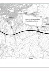
A copy of a GIS layer for the design associated with the 2014 'TR111' protected route corridor.
Documents
M4 relief road , file type: PDF, file size: 303 KB
PDF
303 KB
If you need a more accessible version of this document please email digital@gov.wales. Please tell us the format you need. If you use assistive technology please tell us what this is.
Doc 1 , file type: PDF, file size: 13 MB
PDF
13 MB
If you need a more accessible version of this document please email digital@gov.wales. Please tell us the format you need. If you use assistive technology please tell us what this is.